Introduction
Degrees, minutes, and seconds are the fundamental units used to pinpoint exact locations on Earth’s surface.
1 Degree = 60 Minutes:
Degrees form the broad framework of the planet’s grid, with 360 degrees making up a full circle around the globe. To achieve greater accuracy, each degree is further divided into 60 units (referred to as minutes), and each minute is divided into 60 seconds.
This system allows for incredibly precise measurements, enabling navigators, cartographers, and others to chart positions with accuracy on maps and charts.
By using this division, locations can be specified down to the second, ensuring precise communication and interpretation of geographical coordinates—a critical requirement in fields like aviation, maritime navigation, surveying, and geolocation services.
How Degrees, Minutes & Seconds are Labeled on FAA Sectional Charts
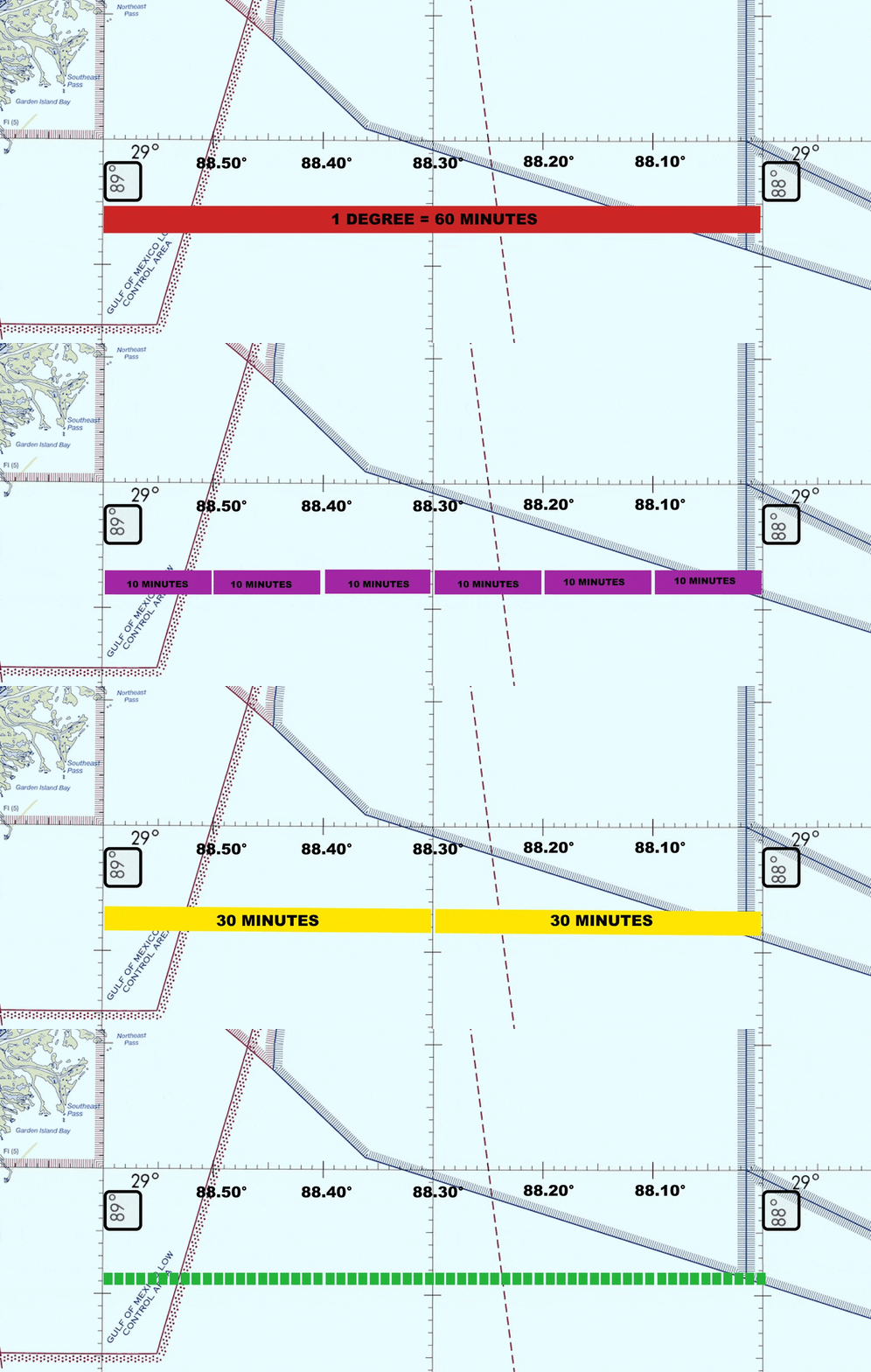
Here’s a visual aid to understand how degrees, minutes, and seconds are measured and labeled on sectional charts. These measurements are broken down as follows:
Red highlights the length of an entire degree, which is equivalent to 60 minutes.
Yellow shows the degree divided in half, representing 30 minutes.
Purple further divides each degree into segments of 10 minutes each.
Green indicates each individual minute, providing even more precise measurement.
*Seconds are the smallest unit, dividing each minute into 60 equal parts, allowing for pinpoint accuracy.
Pinpointing Coordinates on Sectional Charts
Let’s use the example of the Statue of Liberty in New York City
1 Degree = 60 Minutes:
The Statue of Liberty is located at exactly at the latitude and longitude coordinates of 40° 41′ 21″ N, 74° 2′ 40″ W. In other words:
- Latitude: 40 degrees, 41 minutes, 21 seconds North is written as 40° 41′ 21″ N.
- Longitude: 74 degrees, 2 minutes, 40 seconds West is written as 74° 2′ 40″ W.
In these examples:
- Degrees are marked with a ° symbol.
- Minutes are indicated by a ‘ symbol.
- Seconds are shown with a ” symbol.
These annotations help you precisely define any location on Earth, whether for mapping, navigation, or geographic analysis.
Example: Statue of Liberty
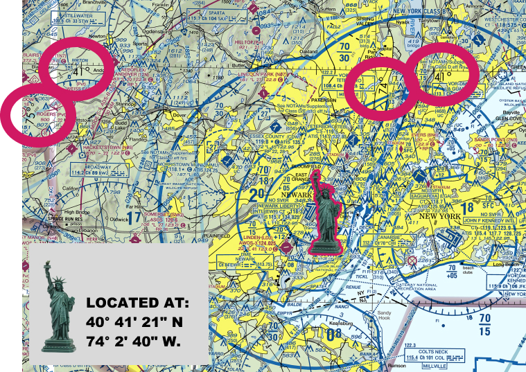
In this example, let’s examine the latitude and longitude of the Statue of Liberty. The visual aid below highlights these coordinates on a sectional chart. We’ve marked the relevant areas with hot pink circles to show the degrees and labeled the landmark with its icon.
For now, use this visual to familiarize yourself with how coordinates are represented and located on a sectional chart.
In the upcoming section, we’ll guide you through practice exercises, showing you step-by-step how to locate specific places given a set of coordinates, and how to find the coordinates of a mystery airport.
Latitude of Statue of Liberty:
Latitude: 40 degrees, 26 minutes, 46 seconds North is written as 40° 41′ 21″ N.
Degrees (°): The degree symbol (°) represents the largest unit of latitude, showing how far north or south the point is from the equator. In this example, 41° indicates a position 41 degrees north of the equator.
Minutes (‘): Each degree is divided into 60 minutes, denoted by the ‘ symbol. In this example, 26’ shows that the position is 41 minutes past the 40th degree of latitude.
Seconds (“): Each minute is further divided into 60 seconds, represented by the ” symbol. Here, 21″ specifies 2 seconds past the 41st minute of latitude.
Longitude of Statue of Liberty:
Longitude: 74 degrees, 2 minutes, 40 seconds West is written as 74° 2′ 40″ W.
Degrees (°): The degree symbol (°) indicates the number of degrees east or west of the Prime Meridian. In this example, 74° shows a position 74 degrees west of the Prime Meridian.
Minutes (‘): Just like latitude, each degree of longitude is divided into 60 minutes, marked by the ‘ symbol. Here, 2’ shows that the position is 2 minutes past the 74th degree of longitude.
Seconds (“): Each minute of longitude is split into 60 seconds, denoted by the ” symbol. In this case, 40″ indicates 40 seconds past the 2nd minute of longitude.
Exercise 1: What Are The Coordinates of Monticello Airport?
Practice with the following exercise to learn how to find specific locations on sectional charts.
What are the Coordinates of the Monticello Airport?
In this exercise where we’ll walk through finding the coordinates for Monticello Airport. Here’s how we’ll break it down:
- Step 1: Locate the Airport on the Sectional Chart: Find Monticello Airport on the sectional chart. Look for the airport icon and identify its approximate location.
- Step 2: Find Nearest Latitude and Longitude Points: Determine the closest latitude and longitude lines surrounding the airport. These lines will help you zero in on the airport’s precise coordinates.
- Step 3: Count Along the Tick Marks: Use the tick marks between the latitude and longitude lines to measure the exact position of the airport. Count the ticks to pinpoint the exact coordinates.
By following these steps, you’ll gain a clear understanding of how to determine the coordinates of any location using a sectional chart.
Let’s walk through each step using visual aids taken from sectional charts:
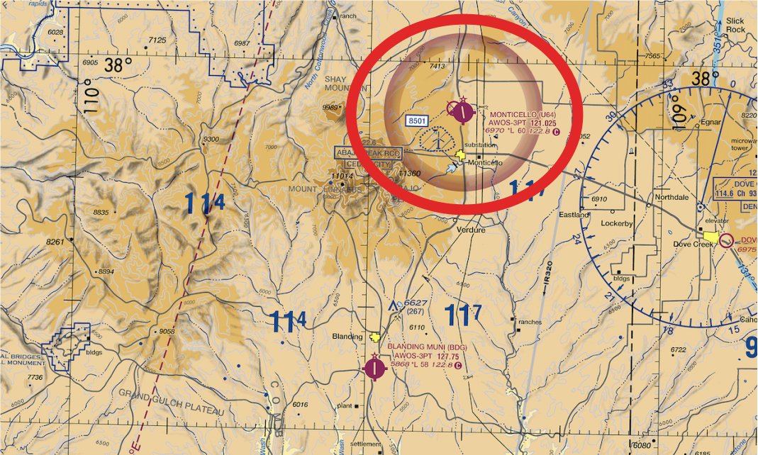
Step 1: Locate Monticello Airport on the Sectional Chart:
Step 2: Find Nearest Latitude and Longitude Points:
- Find the visible latitude lines that are north and south of the airport. In this case, the closest latitude is 38° north.
- Next, find the longitude lines that are east and west of the airport. In this case, the they are 109° and 110° degrees.
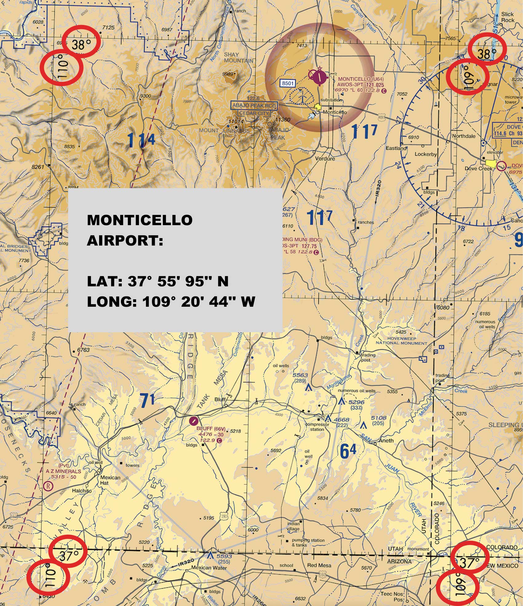
Step 3: Count Along the Tick Marks (Determine Where They Intersect at Monticello Airport):
-
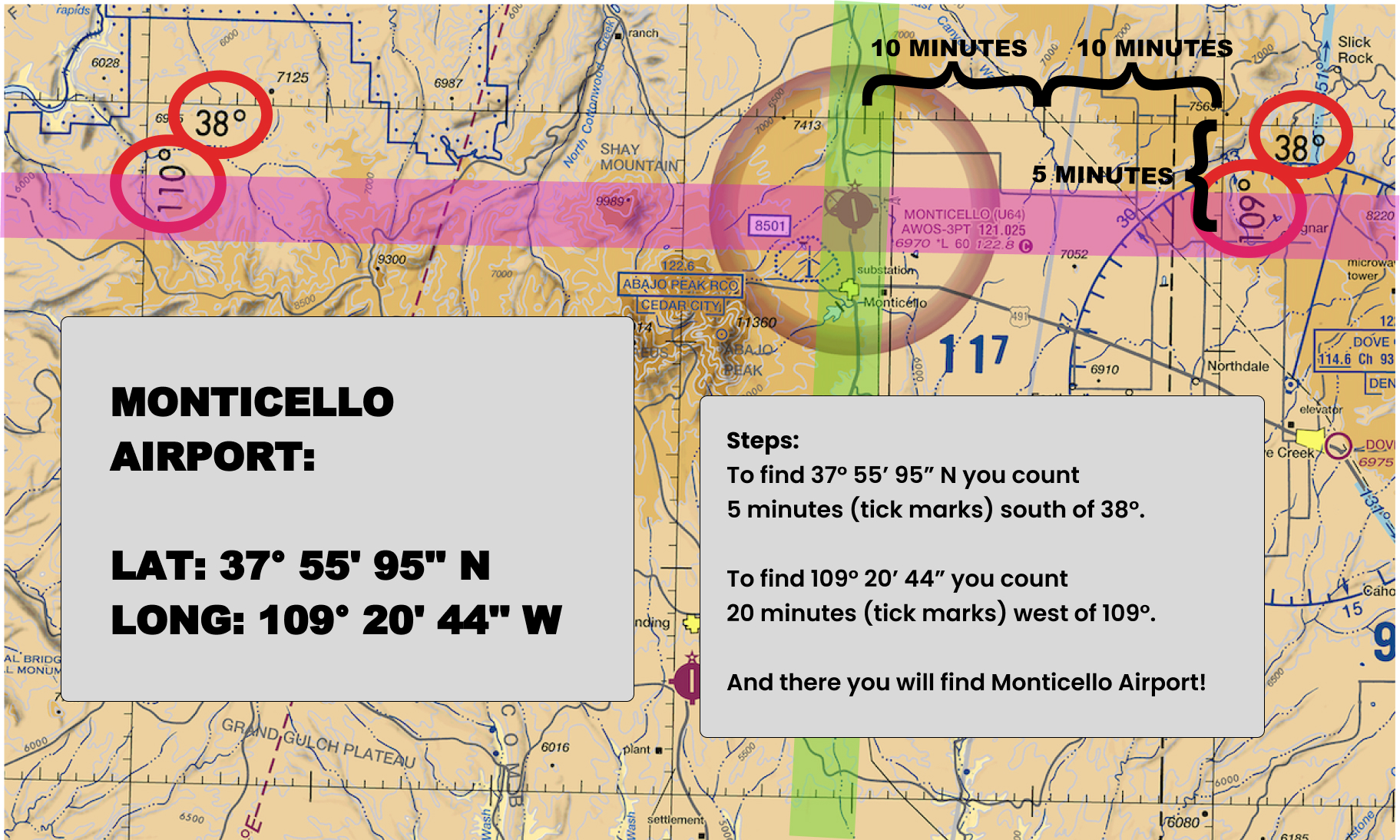
Now, using what you know about degrees, minutes, and seconds, determine how many minutes away from the latitude and longitude lines the airport is located.
-
As shown in on the sectional chart below, Monticello Airport is 20 minutes west of 109° longitude, and 5 minutes south of 38° latitude.
-
This puts Monticello Airport at exactly at (37° 55′ N, 109° 20′ W).
Exercise 2: What “Mystery Airport” is at the following coordinates?
Practice with the following exercise to learn how to find specific locations on sectional charts.
What are the Coordinates at:
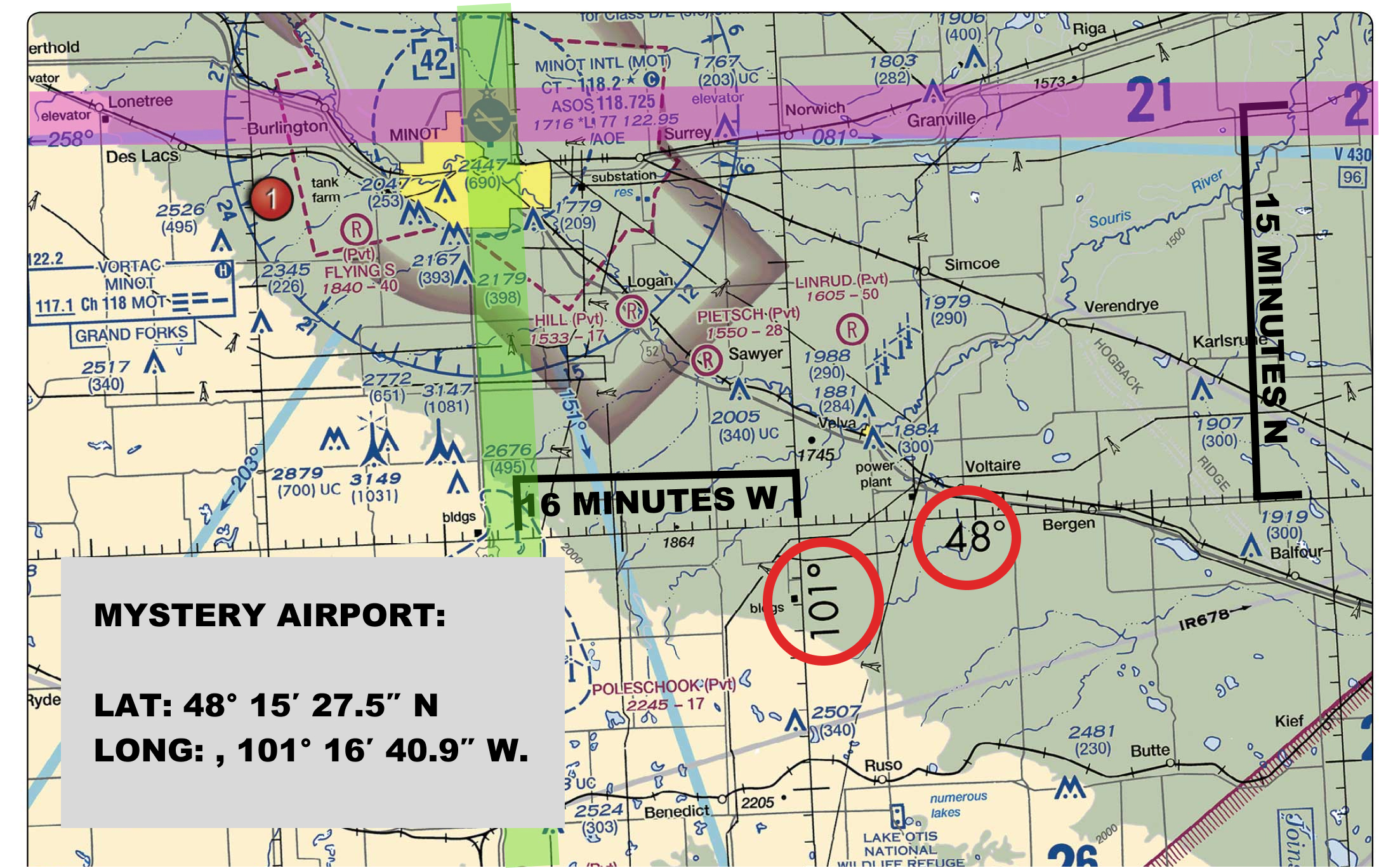
Lat: 48° 15′ 27.5″ N
Long: , 101° 16′ 40.9″ W.
In this exercise where we’ll guide you through the process of finding an airport at a mystery location using given coordinates. Here’s how we’ll approach it:
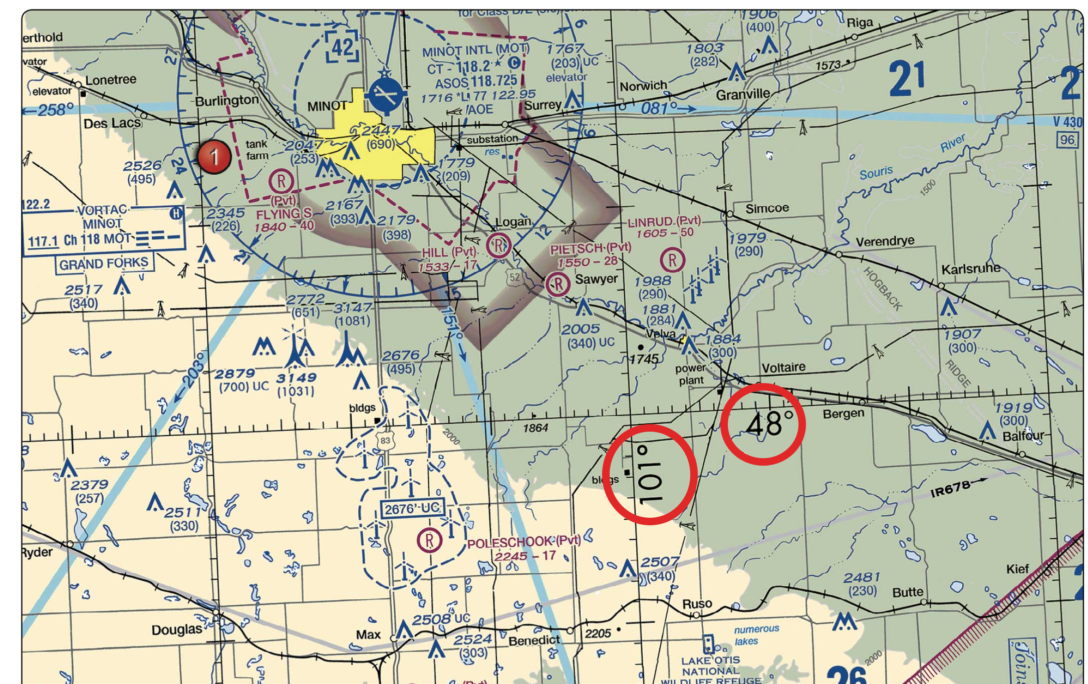
- Step 1: Locate the Coordinates: You’ve been given specific latitude and longitude coordinates, Lat: 48° 15′ 27.5″ N, Long: 101° 16′ 40.9″ W. Start by finding these coordinates on the sectional chart. Look for the nearest latitude and longitude lines that match the given coordinates.
- Step 2: Count Along the Tick Marks: Once you’ve located the general area where the coordinates intersect, use the tick marks on the chart to pinpoint the exact location. Count the divisions carefully to accurately determine the precise spot where the latitude and longitude meet.
- Step 3: Identify the Mystery Airport: With the exact coordinates pinpointed, identify the airport located at this spot. Look for the airport icon and any additional details that confirm its identity.
By following these steps, you’ll learn how to use coordinates to find specific locations on a sectional chart and uncover the mystery airport’s location.
Step 1: Locate the Coordinates:
Step 2: Count along the tick marks:
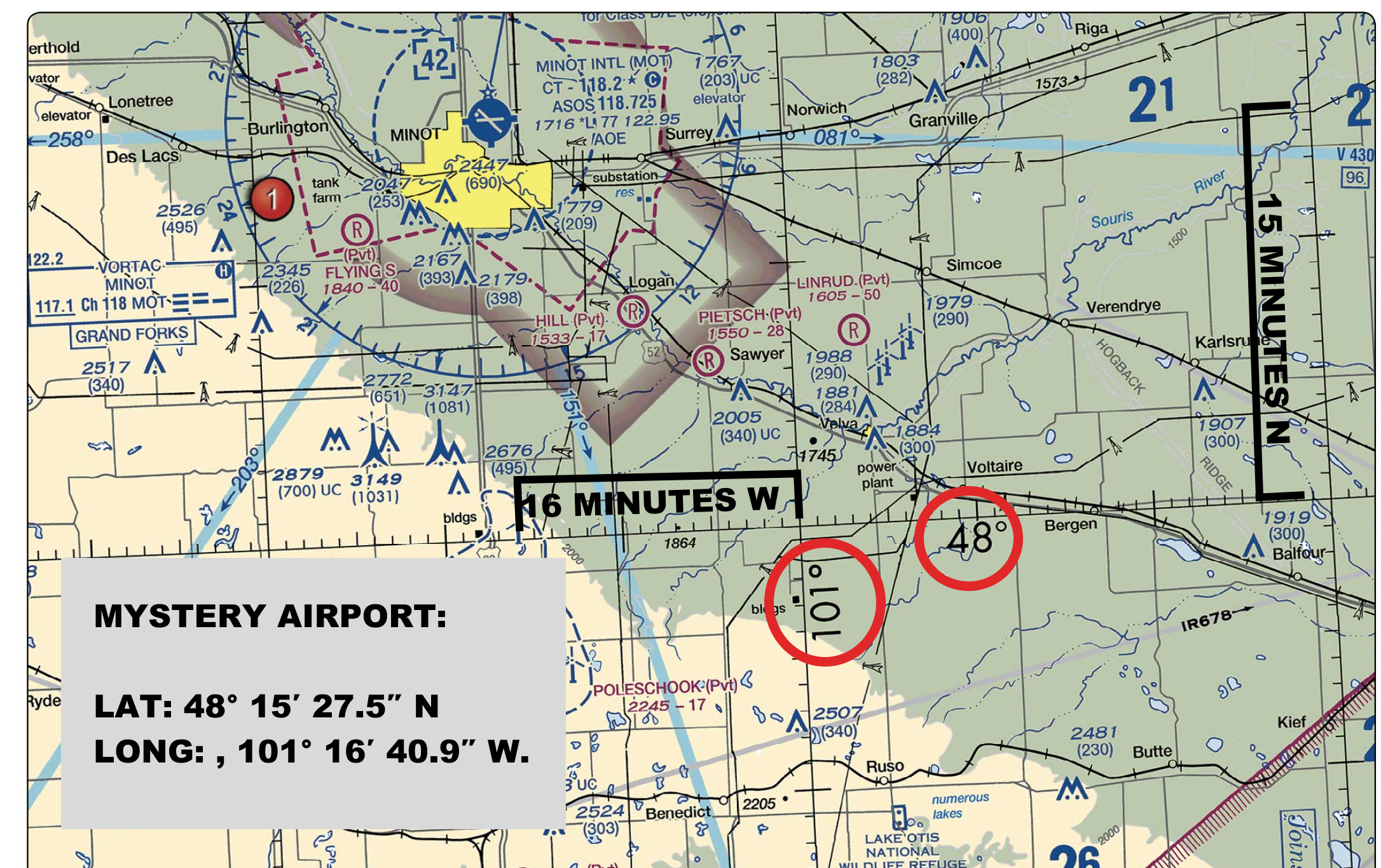
Step 3: Identify the Mystery Airport by Finding Their Intersection Point
-
The answer is Minot Airport (MOT)!)
