MOA: Military Operation Area
Military Training Exercises: Exercise Extreme Caution
A Military Operations Area (MOA) is a designated airspace zone where military aircraft conduct various training exercises, such as combat maneuvers, air-to-air operations, and low-altitude tactics. These areas can involve high-speed, abrupt movements, and dynamic flight patterns that pose unique risks to other airspace users, like drone pilots.
While flying in an MOA does not require prior authorization, pilots must exercise extreme vigilance. Military aircraft may operate at high speeds, rapidly change altitudes, or engage in complex maneuvers that can be challenging to predict.
Key tips for navigating near or within an MOA:
- Check the MOA’s status: Use resources like sectional charts, 1-800-WX-BRIEF, Notices to Air Missions Broadcasts (NOTAMs), or contact the controlling agency to determine if the MOA is active.
- Maintain situational awareness: Monitor the appropriate frequencies for updates and announcements from military aircraft or the control facility.
- Plan alternative routes: If possible, avoid active MOAs to minimize the risk of conflict with military operations.
Example: SUNNY MOA
For example, when looking at the sectional chart, you might see the SUNNY MOA. This will provide essential information such as its name, altitude range, operational hours, and the radio frequency to contact for coordination. The chart will also indicate the control facility responsible for the area.
Figure 1
SUNNY MOA

Figure 2
BORDER OF SECTIONAL CHART

MTR:
Military Training Route
Designated Corridors for Military Training Flights
Military Training Routes (MTRs) are designated corridors in the airspace where military aircraft conduct low-altitude, high-speed training flights where pilots to practice navigation and tactical maneuvers in realistic conditions.
Drone pilots operating near MTRs must be highly vigilant, as these routes can involve low-flying and fast-moving military aircraft, often operating below 1,500 feet.

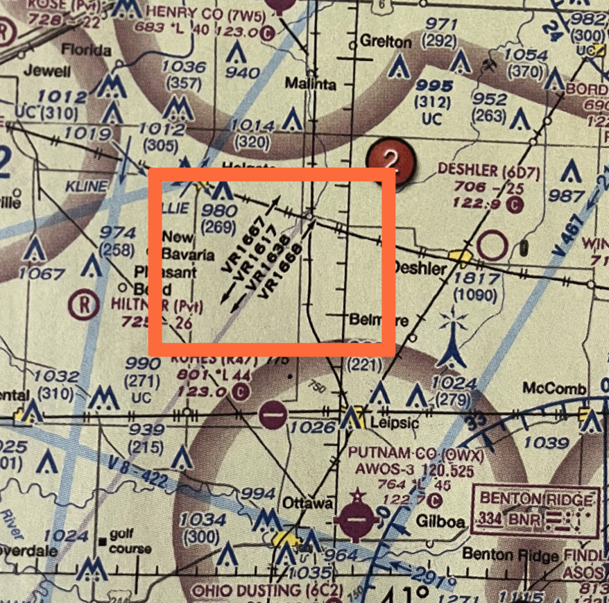
Above: Hover over the image to zoom in on the Military Training Route showcased in red.
Types of MTRs:
VFR (Visual Flight Rules) Corridors
- VFR MTRs rely on clear weather and good visibility, allowing military aircraft to operate based solely on visual references.
IFR (Instrument Flight Rules) Corridors
- IFR MTRs, on the other hand, involve navigation using instruments, enabling operations in various weather conditions and with limited visibility.
IFR and VFR Routes on Sectional Charts
On sectional charts, Military Training Routes (MTRs) are identified by a unique code consisting of either three or four numbers. This code provides essential information about the type of route and its altitude range:
Example of VFR Corridor on Sectional Chart:

IFR and VFR Routes on Sectional Charts
Four Numbers: Below 1,500 feet AGL:
If the MTR code contains four numbers, this shows that the route stays entirely below 1,500 feet Above Ground Level (AGL). This makes VFR corridors particularly risky for sUAS operators since military aircraft traveling at high speeds could be operating in the same airspace. Drone pilots should exercise extreme caution in these areas and make sure that VFR MTRs are inactive before flying.
Three Numbers: Above 1,500 feet AGL:
If the MTR code contains three numbers, this indicates that at least a portion of the route extends above 1,500 feet AGL., posing less risk to drones but potentially impacting general aviation.
| Example | Type | Explanation | Altitude |
|---|---|---|---|
| VR1204 | Visual Flight Rules (VFR) | Flown using visual cues; requires clear weather and visibility. | Entirely below 1,500 feet AGL |
| IR1506 | Instrument Flight Rules (IFR) | Flown using instruments, allowing operation in various weather conditions. | Entirely below 1,500 feet AGL |
Note: Four-digit routes (like VR1204 or IR1506) always indicate flights conducted entirely below 1,500 feet Above Ground Level (AGL).
| Example | Type | Explanation | Altitude |
|---|---|---|---|
| VR120 | Visual Flight Rules (VFR) | Flown using visual cues; requires clear weather and visibility. | Extends above 1,500 feet AGL |
| IR150 | Instrument Flight Rules (IFR) | Flown using instruments, allowing operation in various weather conditions. | Extends above 1,500 feet AGL |
Note: Three-digit routes (like VR120 or IR150) always indicate that flights can operate above 1,500 feet Above Ground Level (AGL).
MOA & MTR Sectional Chart Practice
Practice identifying and interpreting different Military Training Routes (MTRs), including both VFR (Visual Flight Rules) and IFR (Instrument Flight Rules) corridors.
Recognize whether they are above or below 1,500 feet AGL.
3 Digit MTRs (Routes Above 1,500 feet AGL)
VR413
VR413 is a Visual Flight Rules MTR.
- It follows Visual Flight Rules (VFR), meaning pilots rely on clear weather and good visibility.
- The three-digit number (413) means this route is above 1,500 feet AGL.
IR126

IR216 is an Instrument Flight Rules MTR
- It follows Instrument Flight Rules (IFR), meaning pilots can fly in various weather conditions and with limited visibility, relying on instruments.
- The three-digit number (216) means this route is above 1,500 feet AGL.
4 Digit MTR (Routes Below 1,500 feet AGL)
VR1175

VR1175is a Visual Flight Rules MTR.
- It follows Visual Flight Rules (VFR), meaning pilots rely on clear weather and good visibility.
- The four-digit number (1175) means this route is below 1,500 feet AGL.
Flash Cards
What does a 3-digit MTR number mean?
3-digit = above 1,500
What does a 4-digit MTR number mean?
4-digit = below 1,500 feet AGL.
VR1204
VFR MTR, below 1,500 feet AGL.
4-digit = below 1,500 feet AGL.IR1506
VFR MTR, below 1,500 feet AGL.
4-digit = below 1,500 feet AGL.VR413
VFR MTR, above 1,500 feet AGL.
3-digit = above 1,500 feet AGL.
IR216
IFR MTR, above 1,500 feet AGL.
3-digit = above 1,500 feet AGL.