Introduction to Latitude and Longitude
Latitude and longitude form a coordinate system that gives every point on Earth a unique “address.” By combining these two measurements, we can pinpoint exact locations.
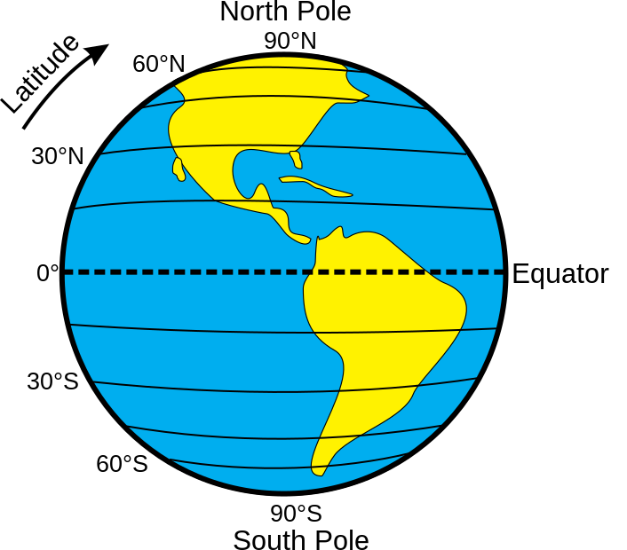
Latitude:
Latitude lines run horizontally East and West around the globe and measure the distance north or south of the Equator, which is the starting point at 0°.
Latitudes are measured in degrees, and they range from 0° at the Equator to 90° at the poles.

Lines of Latitude running horizontally around the Earth
Longitude:
Longitude lines run vertically from the North Pole to the South Pole, measuring the distance east or west of the Prime Meridian.
The Prime Meridian is the starting point at 0° longitude, passing through Greenwich, England. These lines help us determine how far a place is from this central reference point.

Lines of Longitude running vertically around the Earth
How Latitude and Longitude Work Together:
Latitude and longitude form a coordinate system that gives every point on Earth a unique “address.” By combining these two measurements, we can pinpoint exact locations.
Example: The coordinates (40°N, 74°W) will land you in New York City.


The Equator & Prime Meridian
Latitude and longitude form a coordinate system that gives every point on Earth a unique “address.” By combining these two measurements, we can pinpoint exact locations.
Defining the Equator:
The Equator is like an imaginary line that wraps around the middle of the Earth. It’s at 0 degrees latitude and is used to measure how far north or south you are.
It’s perfectly in the middle between the North and South Poles.

Defining the Prime Meridian:
Prime Meridian (0°): Divides the Earth into the Eastern and Western Hemispheres.
Think of the Prime Meridian as an imaginary line that runs from the North Pole to the South Pole. It’s used as the starting point for measuring distances east and west on Earth and is set at 0 degrees longitude.
The Prime Meridian runs roughly Europe and Africa.

Latitude, Longitude and Drone Flight
In FAA Sectional Charts latitude and longitude are used to indicate the positions of designated landmarks, airports, runways, etc.
Latitude and Longitude in the Field:
When mapping a flight path, a drone pilot uses latitude and longitude coordinates on an FAA sectional chart.
They start by identifying important landmarks or waypoints with their coordinates, then plot and connect these points on the chart.
This planned path helps the pilot navigate accurately, stick to regulations, and maintain safety and precision during the flight.
Charting Lines of Latitude
The equator, at 0° latitude, divides the Earth into Northern and Southern hemispheres.
There are parallel lines called lines of latitude that help with navigation and locating places on the globe.
Latitude coordinates show how far north (N) or south (S) a location is from the equator, going from 0° at the equator to 90°N at the North Pole, and from 0° at the equator to 90°S at the South Pole.
These coordinates help pinpoint locations on Earth and give insight into their positions, from the warm equator to the cold poles.
Charting Lines of Longitude
Picture an invisible line from the North Pole to the South Pole – that’s longitude.
It helps measure how far places are east or west of the prime meridian, which is at 0° longitude in Greenwich, England.
Just like latitude lines show north-south positions, longitude lines help us understand east-west locations.
Degrees go from 0° to 180° eastward and from 0° to 180° westward, adding up to 360°, reflecting the Earth’s round shape.
In the contiguous US, the states are within 67° to 125° W longitude.

