Introduction
Features like hills, valleys, and large buildings can drastically change wind patterns, creating unpredictable gusts and turbulence.
These local wind conditions often differ from the broader area and can lead to unexpected gusts or downdrafts that impact your drone’s stability and control.
Exam Prep
On the Part 107 exam, you’ll encounter images of sectional charts and be asked to identify all kinds of information
Understanding Wind Types in Aviation
Here’s a quick breakdown of the key wind phenomena that every drone pilot should recognize.
Wind Shear
While wind shear can occur at all altitudes, it often occurs near passing frontal systems, thunderstorms, and temperature inversions, particularly when winds exceed 25 knots.
Microbursts:
Microbursts are intense, localized downdrafts within a thunderstorm, causing sudden and powerful wind gusts that can exceed 100 mph and pose significant dangers, especially to aviation.
High Winds and Wind Gusts
High Winds: Sustained strong winds blowing consistently over a period of time
Wind Gusts: Brief increases in wind speed that can cause abrupt changes in flight conditions.
How Buildings Impact Wind Patterns
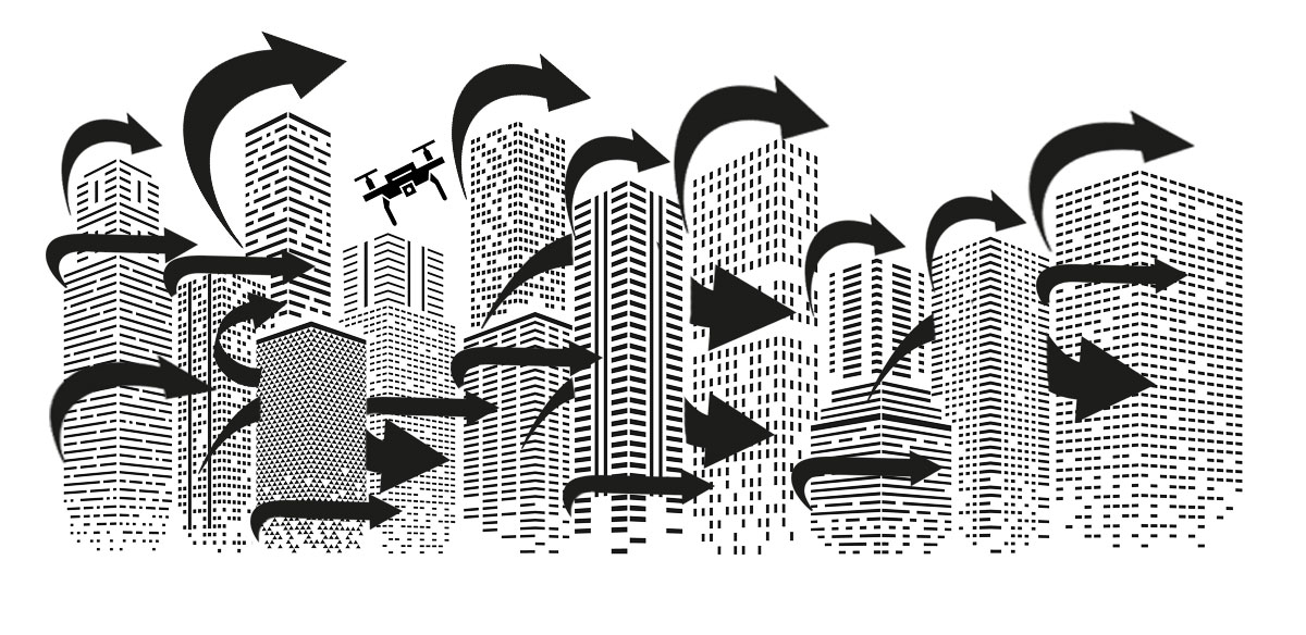
Buildings can significantly disrupt the natural flow of air, causing unexpected wind patterns, and therefore putting great risk to your sUAS in flight.

Wind Gusts and Building Effects
Strong updrafts occur around buildings because when the wind flows toward a building it is is forced to move upward along its vertical surface. This creates vertical air currents that can lift the drone suddenly, potentially affecting its stability and control.
Additionally, the edges and corners of buildings can cause turbulent airflow, leading to rapid changes in wind direction and speed.
These unpredictable gusts can make it difficult for the Remote PIC to maintain steady flight and avoid obstacles, increasing the potential for crashing into buildings, loss of maneuverability, or total loss of control as your UA gets swept away by the wind, never to be seen again.
How Mountains Impact Wind Patterns
When flying your UA near mountainous terrain, understanding the wind dynamics on both the windward and leeward sides of a mountain is necessary.

Windward Side: Updrafts and Their Effects
The windward side of a mountain is where the wind hits the mountain and is forced upward.
Wind flows smoothly up the windward side of the mountain and the upward currents help to carry air higher into the atmosphere. As the air reaches the peak or the crest of the mountain, it begins to descend on the other side.
Leeward Side: Downdrafts and Their Effects
On the leeward side of a mountain, the wind flows downwards, creating a different set of challenges:
- Downdrafts: As the wind descends, it can cause downdrafts that push your UA downward. These downdrafts can be particularly strong and sudden, leading to a rapid loss of altitude. This can force your UA down into the ground.
- Turbulence: The leeward side of a mountain is more prone to turbulence than the windward side. The wind moving down the mountain can interact with the terrain and create turbulent conditions that affect the UA’s stability.
- Wind Shear: The transition between the updrafts on the windward side and the downdrafts on the leeward side can cause wind shear—a rapid change in wind speed and direction over short distances. Wind shear can make the flight more challenging and increase the risk of sudden altitude changes.
Lenticular Clouds
Lenticular Clouds = Turbulence in Mountainous Regions
Lenticular clouds are fascinating and distinctive cloud formations typically found over mountain ranges or other topographic features.
Shape and Appearance: Lenticular clouds are lens-shaped clouds that form perpendicular to the direction of the wind. They resemble saucers or pancakes and can sometimes stack up in a series.
Turbulence: Lenticular clouds can be associated with significant turbulence, especially near their edges. The turbulent air can create challenging flying conditions for unmanned aircraft (UAs) and manned aircraft alike.
Wind Patterns: The presence of lenticular clouds often indicates strong and turbulent wind patterns. Pilots should be cautious of these conditions and plan their routes to avoid areas where such clouds are present.

UA Flight Near Sea & Land Breezes
Sea Breeze
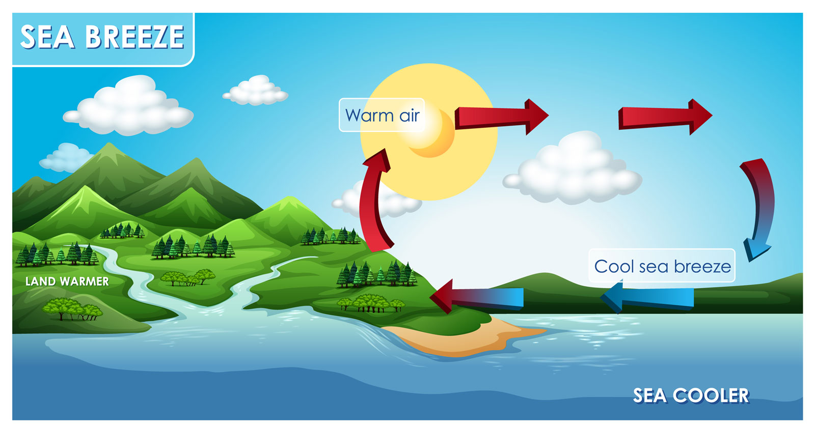
While a sea breeze during the day feels refreshing and cool on the skin, it can cause a lot of turbulence for your UA. These sea breeze drafts can lift your UA unexpectedly, causing turbulence and requiring careful control to maintain a stable flight.
Sea breeze occurs when the land heats up more quickly than the waters of the sea. As the air above the land continues to warm, it rises and create a low-pressure area. Cooler, denser air from the sea then flows into that low-pressure area, creating a breeze.
In other words, this cooler air flowing inland from the sea creates the breeze, which we call a sea breeze.
Land Breeze
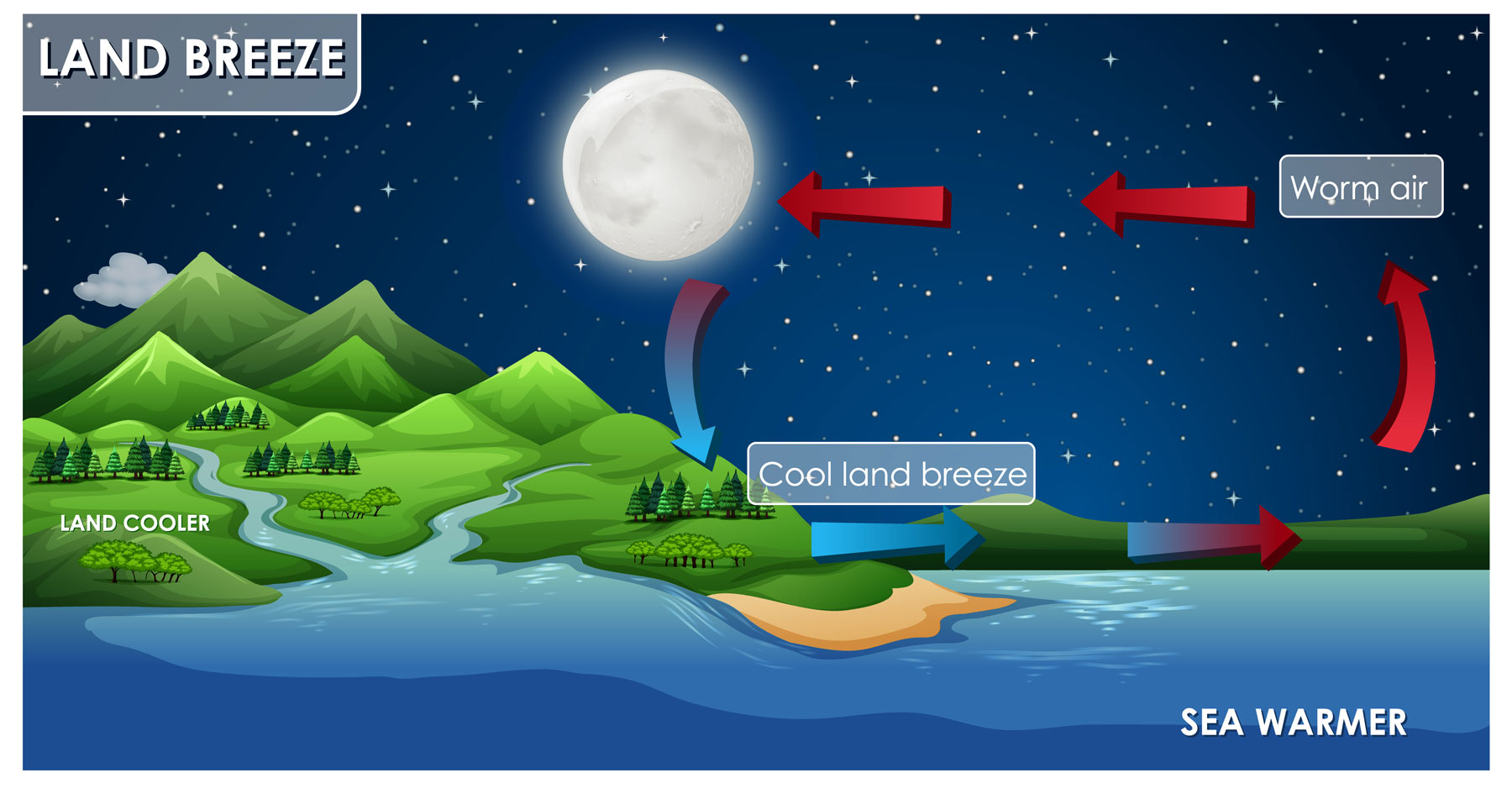
As the sun sets and the temperature begins to drop, land and water start to cool at different rates. This temperature difference creates a natural movement of air known as a land breeze which flows from the land to the water.
Land breezes are generally gentle and can vary in strength based on the temperature difference between the land and water.
After sunset, land cools down faster than the water because it loses heat more quickly. This results in cooler, denser air over the land. This cooler, denser air from the land starts to move toward the warmer water. This movement creates a downward draft that flows from the land to the water.
