Lesson 51

Speed, Altitude, Visibility, and Cloud Ceilings

Small Unmanned Aircraft (UAs) operating under Part 107 regulations are subject to operating limitations, including specified speed restrictions, minimum cloud clearance and visibility requirements, as well as structural altitude limitations, ensuring safe and responsible drone operations within the National Airspace System.

Study Guide

Part 1:

4 Key Operating Limitations

FAA Regulations:

Part 107 sets specific rules for flying small unmanned aircraft systems (sUAS) commercially. Understanding these limitations is key to ensuring safe, legal operations and compliance with FAA regulations.

Maximum Speed

87 knots (100mph)

The sUAS is not allowed to fly faster than 87 knots (100 mph) ground speed.

This rule helps pilots maintain control and stay aware of their surroundings while they’re up in the air.

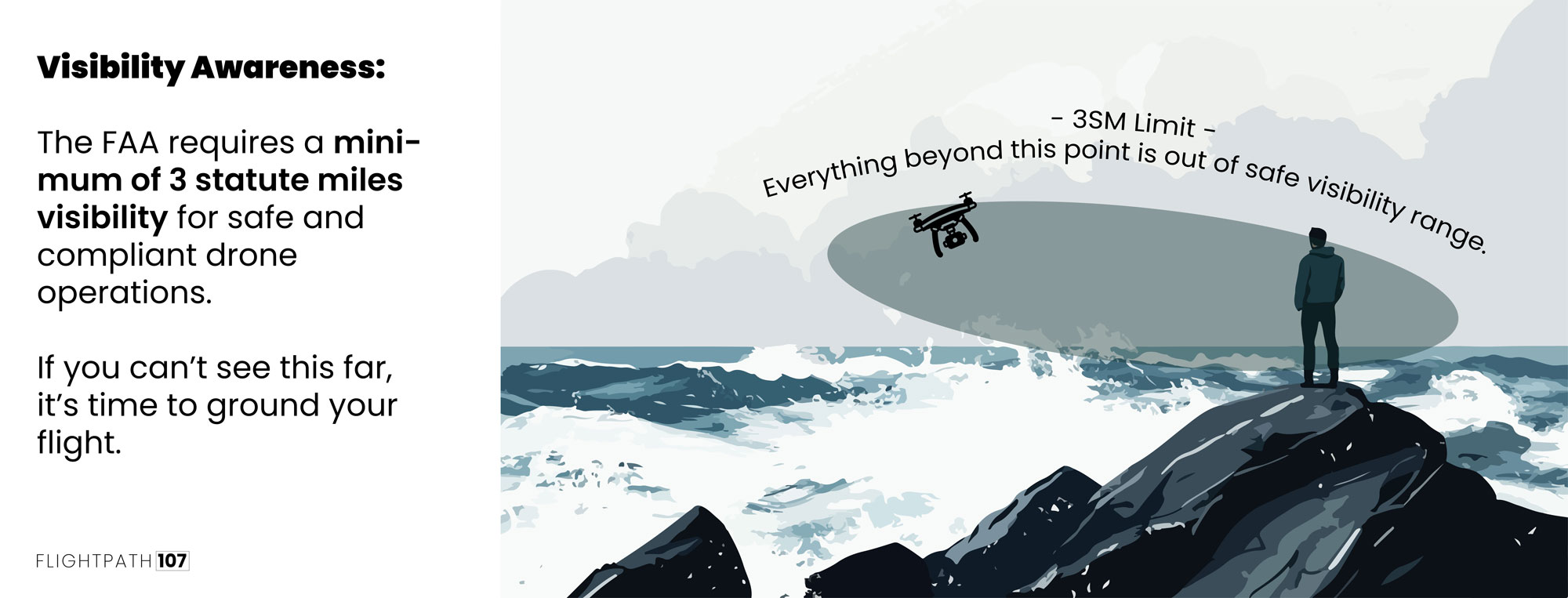
Minimum Visibility

At least 3 statue miles.

During sUAS operations, visibility must be at least 3 statute miles.

This ensures the crew can see the aircraft clearly and navigate safely through the airspace.
Cloud Clearance

500 feet below, 2,000 feet horizontally

The sUAS must stay at least 500 feet below a cloud and 2,000 feet horizontally away from a cloud.

This rule keeps the aircraft visible to the crew and reduces the chance of flying into clouds that could block their view. It’s all about keeping the flight safe and the drone in clear sight.

General Altitude Restrictions

No higher than 400 ft AGL

The sUAS cannot fly higher than 400 feet above ground level (AGL), unless it’s within a 400 foot radius of a structure and stays below the structure’s topmost point.

This rule keeps flights safe by avoiding altitudes that might affect the pilot’s visual line of sight.

Tower Inspection Altitude Restrictions

Within a 400 ft radius of structure’s topmost point

The sUAS cannot fly higher than 400 feet above ground level (AGL), unless it’s within a 400 foot radius of a structure and stays below the structure’s topmost point.

This rule ensures operations around structures are conducted safely.

Examples in the Field

Below are 4 real-life examples where drone pilots need to be aware of these regulations:

Speed Regulations | Anti-Poaching Wildlife Monitoring

A drone operator is tracking wildlife in a national park and hears about possible poachers. Even though it’s urgent, the pilot sticks to the 87 knots (100mph) speed limit. This helps the operator stay in control and fly the drone safely through the park.

Visibility Regulations | Coastal Search-and-Rescue Mission

A drone pilot is on a search-and-rescue mission along a rocky coastline when thick fog reduces visibility to less than 3 SM miles. To stay within legal limits and ensure a successful rescue, the pilot decides to wait until the fog clears and visibility improves.

Cloud Ceilings | Crop Harvest Inspection

A drone pilot is inspecting crop fields for pests when they notice a cumulus cloud forming overhead. To follow the rules, the pilot adjusts the drone to stay 500 feet below the cloud and 2,000 feet away horizontally, ensuring safe and compliant operation while continuing the inspection.

Structure Regulations | Wind Turbine Inspection

In the countryside, a drone pilot is inspecting tall wind turbines, which are taller than 400 feet. To stay within the rules, the pilot keeps the drone within 400 feet of each turbine and does not fly more than 400 feet above the top of the turbine. This ensures the flight remains safe and legal while they check the turbines.

Part 2:

Tower Inspection Calculations

Add 400 feet AGL to the Tower’s Height

To figure out how high you can fly near a tower, you’ll look at the height numbers on the sectional chart. You can fly up to 400 feet above this AGL height as long as you stay within 400 feet of the tower horizontally. You’ll add 400 feet to the given AGL height of the tower and have your answer.
Here’s a step-by-step breka down.

  1. Step 1: Locate the Tower:
    • For each tower, find the height information provided. You’ll see two numbers listed in fraction form: the top half represents the elevation above mean sea level (MSL), and the bottom half, in parentheses, shows the height above ground level (AGL).
  2. Step 2: Find AGL in Parenthases:
    • We want to work with the AGL value because Part 107 regulations focus on maintaining specific altitudes above ground level to ensure safety and compliance.
  3. Step 3: Add 400 ft:
    • According to Part 107, you’re allowed to fly up to 400 feet above the tower’s AGL height, as long as you remain within 400 feet horizontally of the tower.

Sample Calculation:

  • Tower Information:
    • Suppose you find a tower labeled as 1,969 ft (435 ft). Here, 1,969 ft MSL is the height above sea level, and 435 ft AGL is the height above the ground.
  • Calculate the Maximum Altitude:
    • Since you’re allowed to fly up to 400 feet above the tower’s AGL height, you would add 400 ft to the 435 ft AGL height of the tower.
      • Maximum altitude AGL = 435 ft AGL (tower height) + 400 ft = 835 ft AGL.

Practice Exercise

For the following 3 examples, what is the highest you’re allowed to fly to inspect these towers under Part 107 (as long as you operate within 400 ft. of the tower at all times)?

Practice Quiz

Operation Limitations: Speed, Altitude, Visibility, and Ceilings

1 / 7

You're flying your sUAS to document changes in a forest's vegetation over the past year. You notice a storm is approaching and decide to increase speed to finish your mission quickly. What's the maximum speed you can fly your sUAS to stay within Part 107 regulations?

2 / 7

You're preparing to fly your sUAS to document water levels in a wetland area, but there’s morning fog. What is the minimum visibility required to conduct your flight safely and legally under Part 107?

3 / 7

While flying over a nature reserve to monitor wildlife habitats, you notice clouds forming above. What should be the minimum distance between your sUAS and the clouds to comply with Part 107 regulations?

4 / 7

You are documenting tree growth in a hilly area with a tall observation tower. What is the maximum altitude you can fly your sUAS if you stay within a 400-foot radius of the tower and remain compliant with Part 107?

5 / 7

You're out in the field documenting changes in a river’s ecosystem with your sUAS. According to Part 107 regulations, what is the maximum altitude you can fly your sUAS above ground level (AGL) to remain compliant?

6 / 7

(Refer to Figure 23, Area 1) You're ecological study team is tasked with inspecting vegetation around a tower located 8 statute miles north of Allendale Airport (AQX). According to Part 107 regulations, what's the maximum altitude you can legally fly your sUAS if you remain within 400 feet of the tower at all times?

7 / 7

(Refer to Figure 23, Area 3) You’re asked to inspect the lighted tower located 4 statute miles SW of Savannah Hilton Head INTL (SAV). What’s the highest you’re allowed to fly under Part 107?

Your score is

The average score is 0%

0%

According to part 107, what is the maximum groundspeed for a small UA?

A. 87 mph.

B. 87 knots.

C. 100 knots.

Correct Answer: B – 87 knots

Description: The maximum groundspeed for a small UA is:
– 87 knots or 100mph.

Don’t let this question trick you!

Click image to expand

(Refer to Figure 78) You have been contracted to inspect towers located approximately 4NM southwest of the Sioux Gateway (SUX) airport operating an unmanned aircraft. What is the maximum altitude above ground level (AGL) that you are authorized to operate over the top of the towers?

A. 400 feet AGL.

B. 802 feet AGL

C. 402 feet AGL.

Correct Answer: B – 802 feet AGL

Description: Under Part 107, if you are within 400 feet of the structure you can go up to 400 feet above the top of it. The chart shows the tower at 402 feet AGL, making the maximum altitude you can fly above the tower 802 feet AGL.

Note:
Once you find SUX airport you’ll locate the towers 4NM southwest. Here we are able to tell that the tower is still within the fuzzy magenta circle, indicating the Class D airspace it resides in. Due to it being Class D airspace and you would have to get a Certificate of Authorization to operate here.